Alice Piaggio
Description
The SpRC is moving towards an ambitious goal: achieving climate neutrality by 2050. To this end, we have launched an ambitious strategy focused on restoring degraded forest areas to offset our emissions. However, the forest recovery process is complex and requires the integration of new technologies. Through the use of AI, we have designed REFÖREST T, a tool that allows us to assess the viability of land for reforestation, considering both environmental aspects and ecosystem services, as well as the impact on local communities.
Context
The growing climate urgency has highlighted the need to implement effective solutions to reduce greenhouse gas emissions that can integrate both social and environmental perspectives. However, humanitarian organizations often lack adequate tools to make strategic decisions in this area. In response to this challenge, and with the commitment to achieving climate neutrality by 2050, the Spanish Red Cross (CRE) has adopted an emission offset strategy through the reforestation of degraded or fire-affected lands.
The growing climate urgency has highlighted the need to implement effective solutions to reduce greenhouse gas emissions that can integrate social and environmental perspectives. However, humanitarian organizations often lack adequate tools to make strategic decisions. In response to this challenge, and with the commitment to achieving climate neutrality by 2050, the SpRC has adopted an emission offset strategy through the reforestation of degraded or fire-affected lands.
The restoration process for these areas is complex, both due to the management of data from multiple sources and the need to assess the viability of projects from environmental, social, and economic perspectives. To address this complexity, the SpRC has developed the digital tool REFÖREST, which, supported by artificial intelligence, facilitates decision-making by identifying and evaluating suitable land for reforestation. This tool considers not only environmental viability but also the social and economic impact of each intervention.
REFÖREST also provides detailed information on the ecosystem services that reforestation projects can generate, enabling CRE to make decisions with a direct and positive impact on communities near the reforested areas. This is crucial to ensure that compensation actions not only mitigate emissions but also the SpRC to make decisions with a direct and positive impact on communities near the reforested areas. This is crucial to ensure that compensation actions mitigate emissions and benefit local populations.
Before project implementation, REFÖREST allows us to easily evaluate whether the initiatives meet the criteria established by the Spanish Ministry of the Environment, in aspects such as land use, biodiversity, or plantation growth. Additionally, the platform addresses key challenges such as population retention in rural areas and a just transition, contributing to both social well-being and ecological balance.
This tool has a wide range of applications, from improving air quality in urban environments through the reforestation of polluted areas, to revitalizing rural ecosystems, providing ecosystem benefits and recreational spaces for local communities.
Through REFÖREST, the Spanish Red Cross has consolidated its climate strategy, aligning its adaptation and mitigation efforts with international agreements and conventions. The organization not only focuses on reducing and offsetting its emissions but also on generating a positive impact on the communities directly affected by its environmental actions.
Before project implementation, REFÖREST allows us to easily evaluate whether the initiatives meet the criteria established by the Spanish Ministry of the Environment, in aspects such as land use, biodiversity, or plantation growth. Additionally, the platform addresses key challenges such as population retention in rural areas and a just transition, contributing to social well-being and ecological balance.
This tool has a wide range of applications, from improving air quality in urban environments through the reforestation of polluted areas to revitalizing rural ecosystems, providing ecosystem benefits and recreational spaces for local communities.
Through REFÖREST, the SpRC has consolidated its climate strategy, aligning its adaptation and mitigation efforts with international agreements and conventions. The organization not only focuses on reducing and offsetting its emissions but also on generating a positive impact on the communities directly affected by its environmental actions.
Technical details & Operations
Reförest is a web tool designed to facilitate decision-making in reforestation projects, utilizing advanced geospatial data and detailed analysis of the selected plot. The solution works through an automated process that starts with uploading a GIS file with a polygon, selecting a plot using cadastral references, or drawing directly on an interactive map.
Once the area of interest is defined, Reförest gathers data from various official sources, such as the Cadastre, SIGPAC, CORINE, Spanish Forest Map, SOILGRIDS, and climate and ecological databases like GBIF (biodiversity) and wildfire data. The system downloads and processes this information using GIS (Geographic Information Systems) technology, with a focus on spatial big data analysis. Reförest applies digital terrain models, slope and erosion analysis, as well as detailed information on soil type, protected species, habitats, and estimated forest productivity. These tools enable the user to generate a comprehensive report on the suitability of the land for reforestation, highlighting risks, opportunities, and providing specific recommendations.
The integrated GIS viewer in the platform allows users to explore data interactively, with multiple visualization layers that facilitate detailed analysis of the area. This makes Reförest an ideal solution for land managers, forestry engineers, and organizations dedicated to environmental conservation, seeking an advanced platform for scientifically-based reforestation planning and execution.
Reförest allows users, through various input sources such as a cadastral reference, a .gpkg, or a .csv file, to verify the location and main characteristics of the target plot within the application’s viewer, including height, slopes, orientations, area location, terrain features, protected areas, protected species, habitat types, and forest production.
Reförest also generates a climate report and a reforestation report, and it creates numerous files and layers with additional information that complement the reports. The reforestation report can be viewed in .html format.
When selecting land for restoration, information must be gathered from various sources, which are typically scattered across multiple local and regional government websites. By combining digital technologies like AI, a combined search can be performed across multiple sources by entering just one piece of data about the plot under study. This query will yield relevant information, allowing sector technicians to make informed decisions.
Reforestation projects should be viewed as holistic endeavors, where not only the amount of CO2 absorption over the project’s 30-year lifespan is considered, but also aspects such as the ecosystem services provided by the restoration. With REFÖREST, we aim to:
- Develop long-term ecosystem restoration projects with the help of a digital platform that coordinates processes and enables learning from previous experiences.
- Optimize the most relevant ecosystem services, prioritizing those related to climate change mitigation and adaptation, and biodiversity conservation.
- Quantify selected ecosystem services for reporting and/or certification purposes, as well as biodiversity indicators that enable us to assess the effectiveness of our projects through an ongoing adaptive management process.
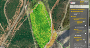
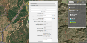
Detail of the viewer with the selected plots for reforestation:
Deployment & Impact
The project has always pursued the triple objective of having an environmental, social, and economic impact.
The environmental impact of the solution is due to the reforestation carried out, thanks to decision-making regarding the benefits of each of the repopulations based on the study of the provided cartography. In environmental terms, reforestation helps combat deforestation and soil degradation, improving biodiversity, restoring natural habitats, and promoting carbon capture. This contributes to climate change mitigation and the improvement of air and water quality in affected areas.
Additionally, the project has had a significant impact on rural areas, as reforestations can boost the local economy by creating jobs in activities such as planting, forest monitoring, and harvesting non-timber forest products.
Similarly, the reforestations carried out have improved the quality of life of local communities by providing them with renewable natural resources (wood, fruits, medicinal plants) and promoting sustainable development. It also strengthens communities’ resilience to natural disasters, such as floods or droughts, reducing associated risks. Involving communities in reforestation encourages civic participation, the creation of community networks, and a shared sense of responsibility toward the natural environment. In many cases, women and young people play a crucial role in these projects, promoting equity and empowerment.
The implementation of the project followed these steps:
- Identification of areas to reforest.
- Study of the land’s feasibility.
- Obtaining the REFÖREST report.
- Execution of reforestations.
Table of the reforestations carried out by the SpRC in recent years :
